Riding Blog

This weblog at mikeuhl.com is the personal web site of Michael "Mike" Uhl. Entries to this weblog and web site represent my personal opinions. The site is not owned, operated, or affiliated with my employer or any organizations other than those owned and operated by Mike Uhl.

Photo (right): That's Lisa and me stopped along US 550, "The Million Dollar Highway," in southwest Colorado on our way north into Silverton, July 2017. 

Entries are copyright (c) Michael A. Uhl, as of date of posting.

You are welcome and encouraged to participate in the discussion on this site. Comments are owned by the poster. I reserve the right to remove any irrelevant, inflammatory, or otherwise inappropriate comments. Questions may be directed to me using the "Post a Comment" feature available on every blog page.

FYI: I ride a 2015 Harley-Davidson FLHTK Ultra Limited Special Edition.

Thank you and please enjoy my site!

Entries by Michael A. Uhl (122)

Tuesday
Sep302014

Going-to-the-Sun Road (US Glacier National Park)

01 Glacier NP Mike sm

(October 1, 2014) As Mitch and I were planning our ride to British Columbia this year, we knew we wanted to ride through Glacier National Park (US)*; it was just a matter of route. You can simply take US 2 through the area. However, in our planning process, I spoke to my sister—an avid camper—and Jim Arscott at Jockeys Cycle—an avid rider—and both emphatically argued that we must ride Going-to-the-Sun Road. This dramatic road snakes along the edges of mountains and lakes within Glacier National Park between St. Mary, Montana in the east—at US 89—and West Glacier, Montana—at US 2—on the west end.

This was Day 7 (Friday, July 4) of our ride. Our destination that day was Canmore, Alberta. We had camped the night before at the Kampgrounds of America (KAO) in St. Mary. It’s a very nice campground and I recommend it, by the way. We had a short ride on Day 6, having ridden from Bozeman to St. Mary. We were thus feeling a little more rested than most other days. That’s very important because you do not want to ride the Going-to-the-Sun Road tired or distracted.

I’m not sure it matters which direction you ride Going-to-the-Sun Road, but I want to let you know that the more challenging segment is on the east (St. Mary) end. We started with the scary end. You should also know that it’s considerably cooler in the park than in the surrounding area. It was in the 70s at the KAO but in the mid 40s on the Sun Road. As we were riding in the early summer when there was still plenty of melting going on along the road, we encountered wet, cool, and slippery conditions. At some points, there was even a little ice on the road. That got our attention!

You do a lot of looking up and down on this road. The Sun Road snakes along the edges of St. Mary Lake and MacDonald Lake, and on the west end, which is also the lower elevation (and warmer) end of the Road, the road traces the path of a creek that changes names along the route and would easily be called a river in most other parts of the country. 

Because words cannot do it justice, I’ll keep the text of this post brief. And though my photos also fail to convey the majesty of the Going-to-the-Sun Road, I offer them here as an inducement for you to go and see this place for yourself. (Click on a photo to display the full-size version of the image.) 

 
We weren’t on the Road long before stopping to take pictures of postcard-like scenery.  

The drop-offs were steep in many places. Neither one of us wanted to walk to the edge of this loose gravel and get a photo looking down. We figured we’d live longer that way. :-)


We seemed to see more now-covered mountains around each turn in the road.


  Falling water and snow were common elements along Going-to-the-Sun Road.
 
OK, I confess: we couldn’t resist backing right up to the edge of this cliff for a photo. Trust me on this, it’s much more dangerous than it looks in the photo.   

Perhaps it was all of the cold rocks and snow —and a lack of sunshine on our Road— that made us feel like we had ridden into a refrigerator.


Some protrusions of rock just look more massive than others…and worthy of a photo.


  Check it out…Mitch has a tanned face but is heavily dressed for the 45°F temperature up on the Road.
10 Going to the Sun Road mt peaks 1 sm   11 Going to the Sun Road mt peaks 2 sm
As majestic as they come...  

Oh look, another mountain peak!


That’s a lot of snow.  

Oh, and yes, there are tunnels too!


16 Going to the Sun Road waterfall 1 sm   19 Going to the Sun Road waterfall 4 sm
We had to ride on the wrong side of the road in places to avoid getting wet from melting snow raining down on the road. If you like waterfalls, you’ll love Going-to-the-Sun Road.   Mitch was impressed enough with this waterfall to stop for a photo.

--------

*I want to make the distinction between the US and Canadian Glacier National Parks. On my ride this summer, I toured both.

Sunday
Sep282014

A Weekend at North Topsail Island, NC

00 Gerry at the beach 1 sm

(9/28/2014) Last weekend I got to spend a couple of days at North Topsail Beach on the coast of North Carolina. My friend Cutter bought a condominium there in January and invited Gerry Z and me along for a ride. (That’s Z in the first photo, right, smiling as we’re about to walk out onto the beach.)

It was great riding there and even better riding home. However, for the two days we were there, it was overcast with on and off again rain. We stuck to riding around the area, which was OK, because there was the ocean, of course, and two fun bars nearby, (1) The Tiki Bar, and (2) The Trailer Bar.

The Tiki Bar

On the first night there, we walked to The Tiki Bar, which is located on New River Inlet Road almost to where the road ends on the north end of the island. We walked out onto the beach—that’s when I took that photo of Z—and headed north for about half a mile and then inland to The Tiki Bar. Cutter’s new condo is in the St. Regis complex of three buildings on the same road about three quarters of a mile to the south. How convenient. :-)

Rob and Victoria own and operate The Tiki Bar and they they had a big bash that evening, celebrating multiple birthdays and the return home from Afghanistan of a wounded veteran named Pat. We gave him a warm welcome befitting someone who has served his country overseas in a war zone. Rob and Victoria served a tasty buffet dinner to all. Thank you Rob & Victoria! I was really hungry, as I skipped lunch and we didn’t reach The Tiki Bar until about eight o’clock.

I have to admit, I’m not much of a drinker and had trouble keeping up. I fell behind early and never caught up. I get a nasty headache from too much alcohol and wisely minimized the shots of fireballs and drank only a few beers. I went home feeling good and headache free. 

One of the highlights of the night was sharing jokes with a young woman named Mo, a nickname for Maureen. Soon after we had arrived, we were sitting out front drinking our first round when up walked this young woman and introduced herself as Mo. She then soon asked if we wanted to hear a joke. For the rest of the evening—about four hours—we exchanged jokes with her. She is of Irish descent and excels at Irish jokes. :-) 

Mike at Buddys sm

Buddy’s Crab House

The next day we slept late and hung around the condo, mostly on the patio overlooking the Atlantic. For lunch on Saturday we rode south to Buddy’s Crab House & Oyster Bar in Surf City. Buddy’s is one of my favorite places because you have a great view of the ocean while you eat. It’s casual dining the way I like it.

Z pointed out at the end of our meal as we were planning our afternoon, “Well, we can’t go east.” We’d just come from the west the day before and weren’t keen on anything in that direction. North ended pretty quickly as we were already near the north end of the island. (Yes, we could have gone inland and then north, but it would have used up the rest of our day.) That left south. We did agree to ride about six miles south to make a quick tour of the island, but we were not eager for a big adventure.

01 Mike at the Trailer Bar sm

The guys were pleasantly surprised when I suggested we just ride around the area and not go very far. (I’m the one who usually likes to ride a couple hundred miles before lunch.) I was more concerned about staying dry as the skies looked threatening, but it worked out great as our next stop turned out to be a lot of fun. I explained to Cutter and Z later that after riding to British Columbia and Western New York this summer, I wasn’t feeling the need to ride many more miles.

The Trailer Bar

Our next stop was the “almost regionally famous” Trailer Bar in North Topsail. They have a great tag line: “Come on in, we only look expensive.” I’m now an official member there, having paid my dues and received my official membership card. I’ve included a copy of my membership card here for proof. :-)

02 Trailer Bar membership card smIt turns out we didn’t actually go in much because they were hosting their annual “The Coast is Clear” charity fundraiser. The tourists were mostly gone—people such as me being the exception. They had a great band playing while we were there called Fried in the Boat. It was a new group comprised of two former separate bands, “In the back of the boat” and “Fried” (something, I forget).

Fried in the Boat did a great job with a mix of country and country-rock tunes. We were very fortunate to arrive just before they started their first set and we stayed for the entire two hours they played. They were a lot of fun and very talented.

Flanagans Pub sm

Cutter’s Bardar & Flanagan’s Pub

One last topic…Cutter has a great memory for hole-in-the-wall bars and the ability at finding them seemingly by instinct. I’ve come to call it “bardar.” I learned of it last year when we rode to Key West. I came to trust him when he signaled a U-turn to investigate yet another pub. They almost always turned out to be fun. (Alabama Jack’s in south Florida comes to mind.)

On the way to North Topsail we stopped at a place called Flanagan’s Pub. We were greeted by a very friendly bartender who served us beer and pickles. It’s worth a stop if you find yourself riding by on US 17 just south of Jacksonville. And just an FYI: the Jacksonville Harley dealership is just down the road.

03 Cutter on the patio sm

They Know How to Party at the Coast

If there was one big lesson I learned this weekend, it was that the people who live at the coast love to party and they're really good at it—comes from lots of practice I imagine.

That last photo, left, is of Cutter on his new patio, with the Atlantic Ocean in the background. He looks happy because he is…he is in his element in North Topsail.

Me, I’m more of a mountains kind of guy. I’ll be riding out there next weekend to see my ladies.

As always…keep the shiny side up.

-The Long Rider


P.S. Special thanks to Kevin Albritton at Jockeys Cycle. He fixed a second oil leak on my bike. My bike is without any problems for the first time in 2-3 years. Can I get an "Amen!"?

Sunday
Sep212014

The Beartooth Highway

01 Beartooth Highway Sign sm

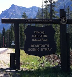
(9/21/2014) Perhaps the most spectacular road my friend Mitch and I rode during our June-July 2014 adventure to British Columbia—by way of the Tetons—was was our transit across the Beartooth Pass on the Beartooth Scenic Byway. This was one of my “must-do” requests when we were planning our ride, even though it would take us 100-200 miles out of the way. Mitch later told me he was very grateful I urged him to include this road as he was as impressed as I was.

I work with a fellow named Matt who has a brother living in Red Lodge, Montana. Red Lodge is at the eastern end of the Beartooth Pass. Matt visited his brother a couple of years ago, in the summer, and drove on the Beartooth Highway. He told me it was the highlight of his trip. Soon thereafter I read an article in HOG Tales that described how great a ride it is. That sealed it for me. I had to ride it for myself.

On top of the world

In a cross-country ride filled with spectacular views and sometimes scary roads, none was more amazing than the Beartooth Highway, at least equal to Going-to-the-Sun Road. It's a section of US 212 that takes you up to almost 11,000 feet, high enough where you find yourself looking down at other snow-covered mountains.

This was Day 5 of our adventure and that morning, in Jackson Wyoming, we were looking up at the Teton range. By late afternoon were looking down at such peaks. We felt like we were on top of the world.
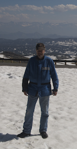
01 BT Pass Mike in snow smSnow falls on the Beartooth Highway even in the summer!

Just two weeks before we arrived there, “an early summer storm” caused the Montana Department of Transportation to close the Beartooth Highway due to “blowing and drifting snow.” At a stop in Yellowstone National Park, Mitch and I asked about the weather conditions on the Beartooth and had been informed of the recent storm by a park employee. He told us we were in luck and that road conditions up there were clear and relatively safe.

In the photo above, right you can see me standing in a field of snow that's at least eight inches deep. Mitch and I enjoyed throwing a few snowballs.

That evening as we ate a late dinner with Mitch’s friend John at a restaurant in Bozeman, John told us that we were fortunate in our timing, as that day—July 2—was the warmest day of the year so far. Much of the snow on the high pass had melted only recently. We got to enjoy relative warmth and sunshine in what can often be a hostile environment.

While we were up there, on top of the world, we stopped several times to play in the snow and stare in awe to the south and southwest (toward Yellowstone) at the seemingly endless chain of mountaintops...trying to see where we had been earlier that day. On our trip, and especially on that day, we had many miles to cover, but couldn't resist pausing and taking in the magnificence of it all.
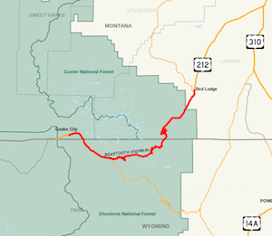
03 BT Pass map smCooke City to Red Lodge

The Beartooth Highway runs from Cooke City, Montana in the west to Red Lodge, Montana in the east but is mostly in the state of Wyoming, as you can see on the accompanying map.

The Beartooth is just northeast of Yellowstone National Park. It thus makes sense that tourists such as ourselves would ride the Beartooth Highway on our way to or from Yellowstone. In our case, we had just departed Yellowstone and were working our way—in a roundabout fashion—to Bozeman, Montana, where we were scheduled for dinner and an overnight stay. (Yes, we scheduled ourselves for a ridiculously long ride.)

Cooke City is a very small town (pop: 120) but a convenient place to fuel your bike before heading into the mountains. Red Lodge, on the other hand, has a population of more than 2,000 people. Like I wrote earlier, my colleague Matt has a brother who lives there. As you can imagine, the winters are cold and the snow that falls tends to stay put until spring. It will not surprise you then that Red Lodge has a disproportionately large number of pubs. :-)

When we were in the Badlands the previous day, Mitch described his ideal house as small with a garage for his motorcycle along a small river out in the country. Coincidentally, we saw exactly these kinds of homes in Red Lodge along Rock Creek. We agreed that perhaps this was a bit too far out in the country. :-)
06 Mitch with both bikes by lake sm

Lots of snow and ice

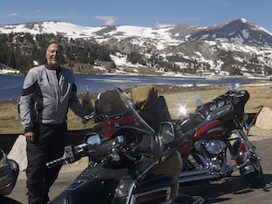
There were snow banks along the road higher than our heads, on July 2!. We stopped at Long Lake for photos, and like another rider—a fellow from California on a BMW—we were impressed by the ice on the lake.

In the photo at right, that's Mitch standing behind our bikes and in front of an icy Long Lake. There was actually a port-o-potty (see photo below) at this parking area. Seemed like a wierd place for such a thing but with Red Lodge another hour to the east and there being no trees along the road for cover, a port-o-potty might look like a bladder's oasis. 

For a little while, we were so far above the tree line that it looked like we had left planet earth and had arrived on Mars. All that was there were rocks. It's remarkable how quickly one can go from thick forests to moon-like terrain when ascending steep mountainsides.

Not much traffic up there...

The Beartooth Pass is open only for about four months each year, opening on the Saturday before Memorial Day and closing in mid October depending on the weather. Given this small window of opportunity to experience this magnificent road and the fact that it was the week of Independence Day, we were pleasantly surprised by how few people were up there.

In the photo, above left, that's Mitch next to his Gold Wing. In the background you can see the port-o-potty and the rider from California, with his BMW. We're at Long Lake.

I doubt we saw more than two dozen other motor vehicles over the entire 60+ mile stretch. Even more surprisingly, we encountered only one other biker (the guy from California).

Mitch and I were impressed with the BMW when its rider told us that he was quite comfortable on what looked to us like a small bike. Given that Mitch was on a Gold Wing and I was on my Harley Electra Glide, I suppose almost any other bike looks small compared to ours.

Highest state border so far

This was the highest state line crossing for me so far. I'm not sure what the elevation was but I'm confident it was close to 8,000 feet if not higher. The accompanying photos of Mitch and me at the state line were on the eastern crossing on the Beartooth Highway.

Oftentimes we want to take photos in front of these kinds of signs but it's not safe. In this case, the Park Service provides a parking area and as I wrote above, we practically had the entire place to ourselves.

Put this one on your bucket list...

This road should be on your top ten ride list along with others such as the Pacific Coast Highway (California 1), Going-to-the-Sun Road (Montana), Blue Ridge Parkway (Virginia and North Carolina), US A1A in southern Florida to Key West, and the Dalton Highway (Alaska).

As always, keep the shiny side up.

-The Long Rider

Tuesday
Sep162014

Labor Day weekend ride to Western New York

Selfie with BooBoo and Tiger sm

(9/18/2014) Over the Labor Day Weekend I rode to Kenmore, New York to see my sister and her family. I also got to spend some time with my friend and former college roommate, known by many of his friends and family as Tiger. In the photo, right, that’s (left to right) me, Tiger, and my sister Margaret.

Just an aside: when we were much younger and living together, my father and brothers and I called Margaret Boo Bear. I now call her Boo Boo and Tiger calls her Bear. Funny how that turned out. My sister and I have always kept in touch and she has known Tiger almost as long as I have.

We took that photo of ourselves outside of the relatively new First Niagara Center, where the NHL Buffalo Sabres hockey team plays. Behind us is a new statue of The French Connection, Rick Martin, Gil Perrault, and René Robert. I’m wearing my denim coat because I was soaking wet from a downpour we rode through as we entered downtown Buffalo.

Tiger was riding the 2000 Road King Classic (FLHRCI) he bought from me in 2009 and Boo Boo was on the back of my 2006 Electra Glide Classic (FLHTCI). With all the construction going on in the area, the rain splashed mud all over our clean bikes and made it look is if we had been “four-wheelin’ “ in the woods. Ugh! I can’t stand a dirty Harley. (I cleaned it as soon as I got back to my sister’s place.)

Me with rifle in Attica sm

Attica, NY

My friend Tiger was born in Corfu, NY, which is locally infamous as a speed trap along NY 33, where NY 77 crosses. His grandparents lived in Attica, not very far away, and are buried there. Tiger thus has a family connection to the area and over the course of the day showed me around his familial territory. Tiger currently lives in the little town of Elma, where one of my uncles used to live.

On Labor Day he took me out for competitive bow shooting, also known as competitive archery. The club where he is a member is on Clinton Street (NY 354), between Elma and Attica. 

That was a new experience for me. In particular, I was fascinated by the appeal of the traditional long bow as compared to the much newer compound bows. Tiger tasked me with using a range finder to ensure the team’s guesses were not unreasonable. It turns out that they didn’t need me for that: they almost always guessed the actual distance to the target within two or three yards. I also kept score and mediated any arguments about where the arrows actually hit the targets. They didn’t really need me for that either: he and his two adult sons, against whom he was competing, were very gentlemanly about any close calls. 

After five hours of that, Tiger took me out to his favorite woodchuck and deer hunting place in Attica. He hunts the chucks in the summer as a favor to the farmer who owns the land in trade for deer hunting privileges in the autumn and winter (during deer hunting season). He kills the woodchucks, which are very destructive to the farmer’s land, with a rifle but hunts deer with a bow.

We saw only one woodchuck, which scampered off into the woods before we any chance at a shot. We patrolled the entire permieter of the meadow. Near the end, Tiger whispered to me, “They know me. They’re not coming out.”

Before we departed for the day, I did pop off a few rounds at a 12-inch diameter rock that was sitting on a tree stump about 175 yards away across the meadow. Tiger's rifle is equipped with a bipod and excellent scope he had carefully calibrated for this meadow. He had me shoot from a prone position in the eight inch tall grass. With the stability of the bipod on the ground and the clarity of the target in the scope, even I could hit the target. ;-)

Donora Industrial Park sign sm

Donora Smog

Because I typically ride through the Pittsburgh area on my way to Kenmore, I decided to stop in Donora, Pennsylvania for a quick look around. I was curious to see what this little town looked like, and I was not disappointed. Like many small American towns, it has not changed much in the last 66 years. My stop in Donora is part of my new effort to slow my riding pace and explore the areas I traverse on my way to other places. I’ve missed too many interesting places and events because I was in a hurry to get somewhere.

Why Donora? At my day job, which I’ve have had for almost 20 years, I work for Lockheed Martin at the US Environmental Protection Agency (EPA). Not surprisingly, I have an interest in environmental issues and the history of air and water quality in the US. In October 1948, an unusual weather pattern combined with intense air pollution in and around Donora, leading to what is now called the Donora Smog. Many people suffocated and thousands of others were made very sick by the dense, dark poison in the air.

For those who like to attack the EPA as a “job killer” and drag on business competitiveness, one need only look at Donora, October 1948 to see what happens when industry is not regulated with regard to emissions into the environment.

In addition to touring the Donora Smog museum in Donora itself, you can also watch a couple of documentaries about the event if you want to know more: (1) The Donora Smog and (2) Rumor of Blue Sky. Unfortunately, I cannot find either of these available for streaming. The Donora Smog video was available on YouTube for a while. Hopefully someone will post it again. Apparently, the Weather Channel has also made a brief documentary about the Donora Smog as well. I haven't seen that one.

Almost there with the bike...

The bike held up well with only an oil leak to irritate me. The primary chain case had a second leak that Kevin (Jockeys Cycle) missed on the first go-round.* It was a small one, but at high speeds over 700-mile distances, I needed to add about half a quart to the primary chain case when I got to Kenmore. The back of my bike had a coating of oil on it, as the back tire captured the leaking oil and sprayed up my bike’s backside.

As of 9/16/2014, that leak has also been sealed. Amen. Thank you Kevin!

Keep the shiny side up.

-The Long Rider


*The original leak was so bad, the abundance of leaking oil made it very difficult to find a small leak when a large one was coating the entire underside of the engine.

Saturday
Sep132014

Tent camping

Badlands Mikes tent 1 sm

(9/13/2014) Touring on a motorcycle and tent camping fit together quite naturally for many riders. We’re already exposing ourselves to the elements. More than once, I’ve felt that getting into my tent and out of the rain was quite cozy compared to riding in the stuff.

On my recent northwest adventure to British Columbia (BC) and nearby states and provinces, my friend Mitch and I packed for tent camping. In my last blog, I advised that you should only pack camping gear if you’re committed to using it because it takes so much space on your bike. However, I’d like to add that having camping gear along—even if you don’t ever use it—offers you a safety net in the event you are unable to find a hotel room or break down in a very remote area that requires an unscheduled overnight stay along the road.

Badlands Mitch tent 1 smSleeping in a tent also offers other benefits. It allows you to

  • stay close to your bike,
  • enjoy nature while you sleep,
  • meet other riders (and campers) of a like mind,
  • offers flexibility on where to stay for the night,
  • and might even save you little money.
On the other hand, tent camping is not so great when the weather turns ugly. Back in the 1980s, I went riding and camping with my friends Steve and Tiger in the Adirondacks. It was Memorial Day weekend and the weather on Saturday and Sunday was great: sunny and highs in the upper 70s. We were camping in the woods—where we weren’t supposed to be—right along Middle Saranac Lake. When we woke up Monday morning, there was four inches of snow on the ground with more falling. Camping in the mountains just about anywhere is dicey. (When Mitch and I rode the bear tooth pass in July, we were informed that it had been closed just two days earlier because of snow.) 

Badlands Mitch bikes tents sm

Proximity to the bikes

When we camped in the Badlands National Park (South Dakota)--which I captured in a bunch of photos, several of which I’ve included here—we slept within 50 feet of our bikes. In addition to a sense of security, such proximity makes unpacking and repacking a much faster process. Other bikers in the area can also link the specific machines to us, which often leads to conversation and maybe even a meal shared together.

Wind

Sometimes you enjoy nature at night, and other times you lie there wondering if nature is going to find its way into your tent and enjoy you—as in a nocturnal meal. On my recent BC trip, we spent much of our time in bear country.

Badlands sunset 2 smWhen we camped in the Badlands, the challenge was wind. I quickly learned how to set up my tent in a 35 mph breeze. Hint: stake the base on the windward corner(s) as soon as is practical. I brought along a dark green Eureka Timberline tent. As you can see in the second photo, my tent was right up against the prairie grass. I learned that wind over prairie grass is loud. I think I slept about three hours total that night.

The photo above, left is one I took of the sunset as seen from our campsite in Badlands National Park.

Fritz from Austin, Texas

Mitch and I also camped at the KAO (Kampgrounds of America) in St. Mary, Montana. After we had set up our tents and finished unpacking the bikes, we sat at a picnic table resting. We then observed a small Japanese-made motorcycle come into our area of the campground. We laughed as we watched an older gentlemen with a long white beard ride right by us on his strange-looking bike. For cargo, he had a single container: a very large box where the passenger seat and luggage rack would go. It was 3-4 feet square and about 18-inches tall.

St Mary KOA Mike 3 sm

We had the pleasure of meeting this unusual man in the KOA store a couple hours later as we got some after-dinner ice cream. His name is Fritz and he was returning from his 12th ride to Prudhoe Bay, Alaska. He was on his way home to Austin, Texas. Mitch was fussing with his cell phone, so I had the pleasure of hearing Fritz’s many stories. When a man has been on the road alone for eight+ weeks, he tends to have a lot he wants to share when next he meets another human being. :-)

Mitch and I regret not getting a photo of Fritz and his contact information. He was fascinating.

In the photo at right, that's me at the KOA in St. Mary, Montana.

What you need to tent camp comfortably

As I wrote above, I use a Eureka Timberline SQ 2XT three-season tent. I love it because I know it will keep me dry even in a heavy rain. It also can trap heat well when I want it to, such as when we were just outside of Glacier National Park. On the other hand, it vents well when you open it up, such as my night in the Badlands. Be sure to buy a sturdy plastic sheet to lay on the ground underneath the tent to keep moisture out and protect the bottom.

I hate being cold, especially when I’m trying to sleep. To stay warm in a tent, you need a quality sleeping bag and an insulated mattress.

I have a somewhat bulky sleeping bag that’s rated for about 20°F. Because I’m carrying it on the bike—as opposed to backpacking—I chose to save money and bought a less compact bag, but still one that will keep me warm.

Badlands Mitch writing at table sm

What I’ve learned from painful experience is that a quality insulated air mattress is essential. On my recent BC trip, I slept well and my Therm-a-Rest mattress was a key contributor. I purchased the large one: it’s 72 inches tall, but just as importantly, it’s wide enough that even if I move around a little in the night, I don’t find myself on the tent floor. My advice is, don’t skimp on the mattress! 

Click on the photo of Mitch sitting at the table writing. Note what’s on the table. That empty Gatorade bottle was mine and it proved very useful. Here’s a tip from experienced campers that I only learned on this trip: take an empty Gatorade bottle or other plastic, disposable bottle with a wide mouth into your tent for the night. It can save you a trip in the night to pee. We older gentlemen can’t hold it all night the way we used to. :-)  

Kid in a candy store

Be warned, if you’re anything like me, going to CampMor’s website or even worse, a local REI store, can be very expensive as you become a kid in a candy store. Make a list before you shop and stick to it.

Other stuff I packed for the trip that was useful was compact, high-tech cookware and a head-mounted light from REI. What I ended up tossing were two freeze-dried dinners I bought at REI. Mitch and I agreed that they were nasty.